Implementation of Motorized Watercraft Exclusion Zones 2026
Please be advised that Motorized Watercraft Exclusion Zones (MWEZ) will be implemented in the Port and Harbour of Toronto, effective July 7 to November 30, 2026.
Established at the request of the City of Toronto, Motorized Watercraft Exclusion Zones enhance the experience and safety of all water users by separating motorized vessels from other non-motorized uses of the water.
All motorized watercraft are prohibited from entering the MWEZ. Zones follow the shoreline and are monitored by the Toronto Police Service Marine Unit to ensure compliance. Any motorized watercraft that enter MWEZ will be subject to fines.
There is also a Reduced Noise Zone everywhere on the lake that extends 400 metres from the shore.
The four MWEZ areas are located at:
- Cherry Beach (150 metres offshore)
- Hanlan’s Point Beach (200 metres offshore)
- Humber Bay Park East (150 metres offshore)
- Woodbine and Kew/Balmy Beach (150 metres offshore)
For any questions contact exclusionzone@torontoharboursafety.com.
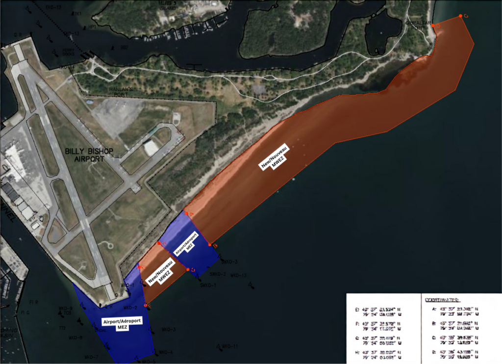
Hanlan’s Point Beach: Coordinates
- New MWEZ in orange
- Existing Billy Bishop Airport Marine Exclusion Zones in blue
A: 43• 37’ 25.345” N
79• 23’ 56.704” W
B: 43• 37’ 21.662” N
79• 24’ 04.046” W
C: 43• 36’ 38.638” N
79• 23’ 13.929” W
D: 43• 36’ 43.286” N
79• 23’ 15.889” W
E: 43• 37’ 33.534” N
79• 24’ 08.528” W
F: 43• 37’ 32.670” N
79• 24’ 17.372” W
G: 43• 37’ 25.419” N
79• 24’ 09.522” W
H: 43• 37’ 30.037” N
79• 24’ 03.262” W
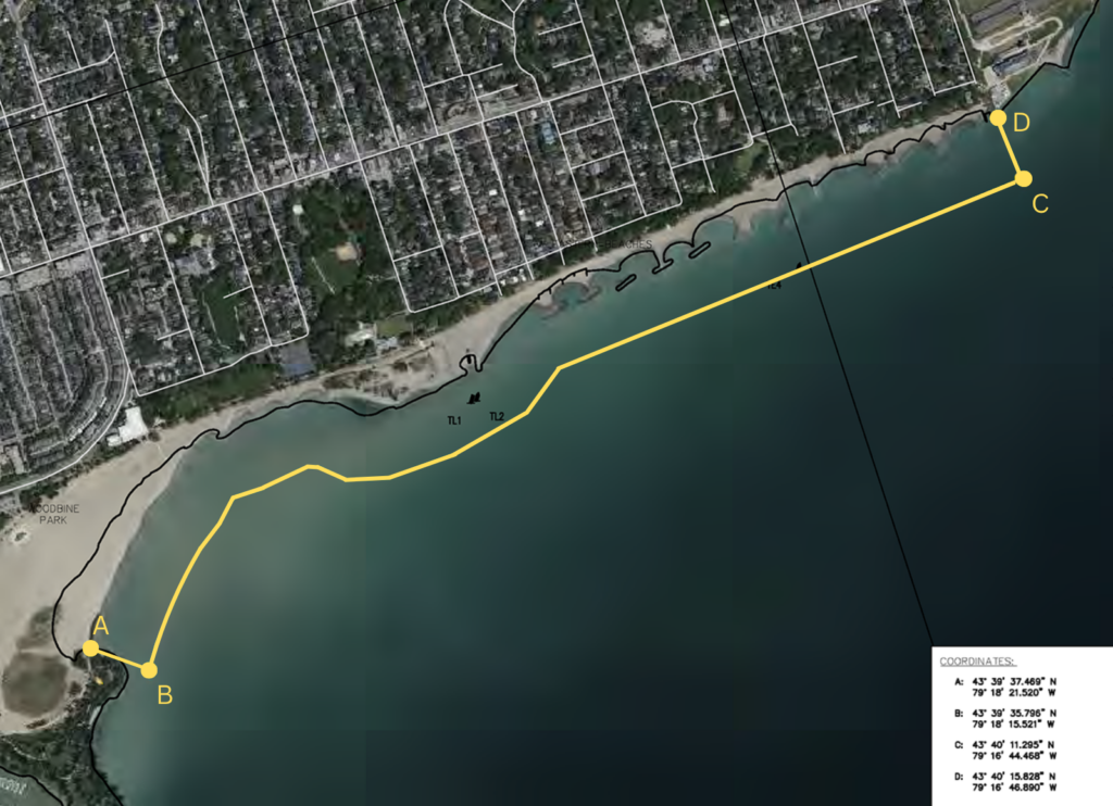
Woodbine and Kew/Balmy Beach: Coordinates
A: 43• 39’ 37.469” N
79• 18’ 21.520” W
B: 43• 39’ 35.796” N
79• 18’ 15.521” W
C: 43• 40’ 11.295” N
79• 16’ 44.468” W
D: 43• 40’ 15.828” N
79• 16’ 46.890” W
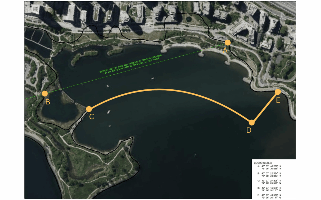
Humber Bay Park East: Coordinates
A: 43• 37’ 27.206” N
79• 28’ 25.541” W
B: 43• 37’ 45.570” N
79• 28’ 16.270” W
C: 43• 37’ 49.538” N
79• 28’ 20.137” W
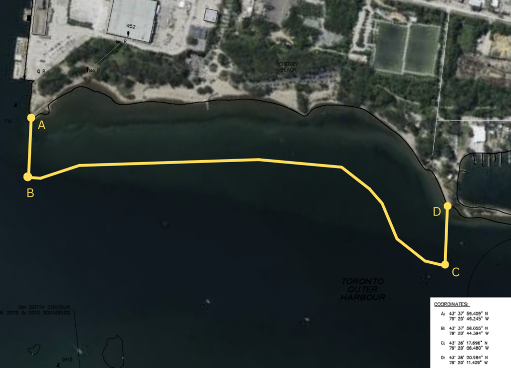
Cherry Beach: Coordinates
A: 43• 37’ 59.409” N
79• 20’ 49.245” W
B: 43• 37’ 56.055” N
79• 20’ 44.394” W
C: 43• 38’ 17.696” N
79• 20’ 06.480” W
D: 43• 38’ 20.984” N
79• 20’ 11.409” W